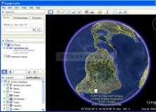
Using the Google Earth Extension‘s simple wizard-driven interface, you can publish your 3D models from AutoCAD® software or select AutoCAD-based products directly into the Google Earth™ application. The free* technology preview allows you to import a Google Earth image into AutoCAD, publish your 3D model to Google Earth, drape a Google Earth image onto a 3D mesh in AutoCAD, and attach time span information to your model.
The version for AutoCAD 2012 family of applications has been updated to have an all-in-product workflow. You no longer need to operate in the Google Earth application separately, but instead you can perform both import and export actions in AutoCAD dialogs with Google Earth embedded inside. In addition, this update also provides functional improvements including: Importing color image from Google Earth and automatic filling geographical information in publish wizard.
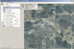
A tool for integrating the maps of your choice into the Virtual Earth API.


Comments